Saturday marks the start of what forecasters predict will be a very active hurricane season, and we’re getting an inside look at the amazing drone technology being used by hurricane hunters. 7’s Karen Hensel has our special assignment report.
Dr. Joseph Cione is a meteorologist on a mission.
Dr. Joseph Cione, National Oceanic and Atmospheric Administration: “I love my job.”
His job is to lead hurricane hunting into the future.
Dr. Joseph Cione: “This plane flies at 10,000, 12,000 feet, 8,000 feet. Why don’t we fly below that? It’s way too dangerous. Way too dangerous.”
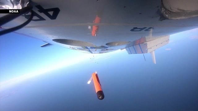
That’s where these lightweight but high-tech drones come in.
Dr. Joseph Cione: “You’re throwing a plane out of a plane. The P-3 behind me is going 220 knots, so you’re jettisoning something out and expecting it to just get its bearings and fly. It sort of comes out in a cylinder. Then you have the wings deploy, gets acclimated and does its thing.”
The drones collect data at low altitudes and transmit it back to the hurricane hunter plane.
Dr. Joseph Cione: “When the storm makes landfall, we’re at the coast. We’re not at 20,000 feet, 10,000 feet. We’re all down here, so when these storms make landfall, we want to know particularly what the winds are.”
Back in September 2022, the winds of Hurricane Ian reached 160 miles per hour as it approached Florida’s southwest coast.
Dr. Joseph Cione: “The biggest flight we’ve had so far is in Ian itself, which that alone, that was a crazy flight.”
Hurricane hunters: “Holy cow!” “Oh, [expletive]!”
Video from inside that plane shows just how crazy it got.
Dr. Joseph Cione: “That initial transect through the western eyewall was, for me personally, the most violent, most turbulent transcect into a storm. And it was so violent that we ended up leaving the storm.”
But not before successfully deploying a drone into Ian’s eye.
Once dropped, its location is marked by a bull’s-eye on this remarkable radar image.
Dr. Joseph Cione: “This thing measured, set world records: 216 miles an hour. We recorded the strongest winds by any drone, anywhere, on this planet anyway. An incredible mission.”
Speaking of incredible, saildrones, like their name suggests, literally ride the ocean’s massive waves.
Dr. Joseph Cione: “So this thing is sitting in the ocean, experiencing 50-foot waves. The saildrone is nice, because it gets us right at the surface. We can see what’s going on in the ocean, because remember, the energy from the ocean is how the storms stay alive.”
Whether it’s flying drones or saildrones, the key is for the data they collect to help improve forecasts here at the National Hurricane Center.
Daniel Brown, NHC: “I think there’s a real future for some of these instruments, because they can fly in areas of the storm that manned aircraft cannot.”
Dr. Joseph Cione: “That’s something that is an absolute must of this program, is to get the data to the people that can make these life-changing forecasts in real time.”
The mission is a personal one for Dr. Cione, a former South Florida resident.
Dr. Joseph Cione: “Spent many, many years in Miami. Loved my time in Miami. If this technology can get implemented, places like Florida, particularly South Florida, are going to benefit quite a bit.”
And we will all benefit from the information gathered by these new forecast tools.
Dr. Joseph Cione: “That’s the overriding mission for NOAA, right? We’re here to protect property and save lives.”
Which is why critical improvements in technology now will lead to better forecasts in the future.
Karen Hensel, 7News.
Copyright 2024 Sunbeam Television Corp. All rights reserved. This material may not be published, broadcast, rewritten or redistributed.


